Getting There - Aneel's Travelogue
< Previous: Visiting | Getting There - Aneel's Travelogue | Next: To Cataviña >
| South of the border | Ensenada, Baja California, Mexico, Monday, 29 June 2009 7:59pm |
|
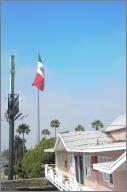
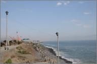
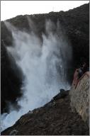
We're in Mexico! In Ensenada, to be more precise, about a block from the enormous Mexican flag that is one of the sights of this city. I'd hoped to be in Ensenada for a midafternoon snack, but we're running a bit behind schedule (no surprise there). Chuck is not feeling well. He thinks it's something he ate. I'd kind of expected this to happen, but it's about two days early, since it must have been something he ate in Pacific Beach last night that did him in, not something on this side of the border. We stopped for breakfast at a place in Ocean Beach in the morning, and he didn't finish his stack of pancakes, and by the time we were in Tecate, he was feeling awful. So we decided to take it fairly easy and not push past Ensenada today. The trip to the border was a little disconcerting. It was hard to believe that the road we were on actually led to a border crossing. We took CA 94 from the outskirts of San Diego to Tecate. Most of the way it was a lonely, winding, two-lane road (once it was one lane with a flagger for some construction). The final turnoff for Mexico didn't even mention that the destination (Tecate 2mi) was in Mexico. We did pass a border checkpoint, and a couple SUVs with Border Patrol markings, and at one point a border patrol helicopter flew over, but otherwise it was really low key. We stopped just short of the border (which we knew, because there was an "International Border 1500m" sign), and filled up on gas. Chuck discovered that his gas can cap didn't actually seal the can either, and my selection of O-rings didn't seem to help. Luckily, I'd brought the pour spout from my gas cans, and that sealed it fine. Then it was across the border... which was a pretty spectacular nonevent. We went through an archway. A light came on, telling us to stop, and then a guy took a look at us out of the corner of his eye and waved us through. We were immediately caught in a traffic jam near Tecate's central square, but we made our way the two blocks to the Tecate beer garden, in the shadow of the brewery. After drinking our free beers, we headed back to the square (where they have free WiFi, but you have to register for an account, which neither of us felt compelled to do. It was at this point that Chuck started to notice just how sick he felt. I wolfed down some chilaquiles, while he just had some guacamole. Then while he sat and rested, I investigated the tourist office on the square, trying to find out where to get our Tourist form (necessary if you're going more than a certain distance from the border). Apparently nobody goes more than a certain distance from the border, because the first two people who I asked in the office didn't know what I was talking about, and had to ask the third person, who pointed me back up the hill to the Aduana (Customs) office. We walked up the hill, with a quick stop at a bank to get some pesos. There are a lot of buildings on that hill labelled "Agencia Aduanal", but none of them are the customs agents. I think they probably have something to do with import/export. They pointed us further up the hill to the archway that we'd used to enter the country. When we wandered around the arch a bit, a man in an INM shirt asked us what we were looking for, and when we said we needed Tourist forms, he took us inside and gave us a form to take down to the bank. After determining the proper line at the bank, handing over the form, and paying the fee, we took the completed form back up to the INM official and were given a second form to fill out. Once that was completed and stamped, we were on our way. My GPS wanted us to go to Ensenada by way of Tijuana (negating the point of entering at Tecate in the first place), and the roads seemed to agree. Even when we found the signs for Mex 3 (to Ensenada) they abruptly changed to Mex 2 (to Tijuana) for a while before switching back. Once we were out of the city, things were much clearer. There was only one road, and occasionally it would assure us that it would eventually get to Ensenada. The road seemed startlingly new. Very fresh, very smooth blacktop. After a little way it became clear why: it's brand new. We caught up with the road crews building the road, complete with more flaggers and pauses to let traffic from the other direction go by. There was one short section that had been torn up in anticipation of resurfacing, but hadn't yet been resurfaced, but even that wasn't as rough as some of the gravel roads I've ridden on near campgrounds back home. The trickiest thing was figuring out how fast we should be going. The speed limits are clearly posted, and I'd switched my GPS over to km, so it gave me my speed in the proper scale. The problem was that when we actually went that speed, we got semis tailgating us and flashing their lights (everyone else just passed us). Eventually, we just followed some cars at the same speed they were going until we determined about how much faster than the posted limit was expected. We passed through some beautiful country. Golden hills in the foreground, blue hills in the background, and small trees dotting the landscape. Dry, rolling rocky hills, with boulders strewn around. Valleys devoted to grape growing (this is wine country, it seems). There were a number of times that I would have liked to stop for a picture, but for almost all of the way, the road had no shoulder. Lots of people had warned me about that, but I hadn't realized the implications. My motorcycle would really not respond well to suddenly being on sand or gravel while going even moderately fast, so the only way to exit the road would be to find a place where we could slow down enough to get off the road gingerly. There aren't a whole lot of those places, particularly not in the (deserted) areas with the good views. Ah well. Eventually, we reached the outskirts of Ensenada and stopped at a vista point to take stock. We decided that we should just relax and spend the night in the city, rather than try to push on, so we made our way to an area with a high density of hotels and picked one that looked good. They gave us a room and invited us to pull our motorcycles in to the courtyard with the pool (under an arch off of the courtyard with parking spaces. We ended up parking behind a truck under an overhang instead, since it seemed kind of annoying to take the bikes all the way in. After a quick swim in the pool, we headed out to La Bufadora, a blowhole about 35km from the town. It turned out to be a really long 35km. The road wound around quite a bit, and there were inexplicable speed bumps in the middle of stretches of road marked at 80km/h (faster than almost all of the sections of Mex 3). La Bufadora appears to be a huge tourist trap. Hundreds of stalls full of tchotchkes, food vendors, and the like. However, they were almost all closed when we got there. I'm not sure whether it's just not the season or the fact that we got there late on a Monday, but it was eerily quiet. Almost the only people there were a bunch of christian harley riders (with Jesus patches sewn onto their biker vests). The blowhole was pretty neat. It's a channel that narrows rapidly, so when a wave comes in, the water is forced up and sprays yards up into the air. I'm not sure it justifies the sheer mass of tourist-marketed junk, but it was interesting to watch. GPS Track: Day 3 167 mi |
|


